Sub-theme leader
So Kazama (Tohoku University)
Outline
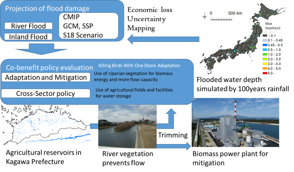
This research will be conducted by four teams that will work on 1: a river flooding analysis, 2: an inland flooding analysis, 3: remote sensing modelling, and 4: a river flow calculation. Both flooding teams will use rainfall data with statistical downscaling from CMIP and apply a physical flooding simulation in Japan. These teams will utilize land use and population in the same scenarios as those of the S18 project. The fourth team will provide simulation parameters for the flooding simulation by channel flow calculations in rivers with vegetation. We will obtain economic flood damage in Japan using simulation results and economic value data. The flood simulation will evaluate various adaptation options by agricultural facilities such as reservoirs and paddy fields, and by removing riparian vegetation to maintain the flow capacity. An evaluation and discussion on the use of agricultural facilities will require the cooperation of sub-theme 3(4) to seek the optimal management of water resources. Maintaining river flow capacity is one of the most useful countermeasures to prevent floods and involves tree trimming and excavation. The remote sensing technology of the third team will estimate vegetation mass and the necessity of vegetation removal. The hydraulic simulation of the fourth team will provide a relationship between the roughness of river flow and vegetation mass. The removal of vegetation can be used for biopower generation as a mitigation measure. This work will contribute to flood simulation and evaluate the reduction of flood damage and carbon emissions as adaptation and mitigation, respectively. Our final target is to develop an understanding of adaptability in Japan in view of co-benefit and cross-sector work.
Goals
The hydraulic model simulation will estimate the damage to river and inland floods and evaluates some adaptive options, namely, the use of agricultural facilities and excavation and tree trimming in rivers. The co-benefit of agricultural facility use is discussed using water use adaptation by sub-theme 3(4). Tree trimming will be evaluated for mitigation as bio-energy generation. These adaptabilities will be shown numerically as mapped information.
Target items
The research is to be conducted by four team members who are Kazama and Yoshiya Touge (Tohoku University), Seiki Kawagoe (Fukushima University), Yuji Kuwahara (Ibaraki University), and Shuichi Kure (Toyama Prefectural University). Multi-GCMs (Global Climate Models) and scenarios will be used for the future flooding projections. The projections will involve:
- Simulation of river flooding using geographical information in Japan,
- Simulation of inland flooding using geographical information in Japan,
- Evaluation of economic damage of both floods,
- Riparian vegetation modelling using remote sensing,
- River flow simulation with vegetation roughness estimated by the riparian modelling,
- Evaluation of adaptation and mitigation by vegetation removal in rivers,
- Estimation of economic damage reduction by river excavation,
- Estimation of economic damage reduction by use of agricultural reservoirs,
- Estimation of effect of flood reduction for paddy field use, and
- 田んぼダムのDiscussion on land use and architecture control policies.
S18 scenarios will be used for the future projection of each adaptation.
Adaptation options
- River excavation,
- River vegetation removal,
- Use of agricultural reservoirs,
- Use of paddy fields,
- Land use control, and
- Architecture control.